Following the announcement of the recommended navigation methods, reference routes and public routes under their respective jurisdictional waters by the MSA of Zhoushan, Lianyungang, Shandong, Liaoning, Tianjin, and Hebei MSA, in order to regulate the ship navigation order along the coast of Nantong and to improve navigation efficiency and safety, Jiangsu and Shanghai MSA jointly issued a Notice on February 4, 2024 on the announcement of the public routes and anchorages along the coast of Nantong. The main content of the Notice is as follows:
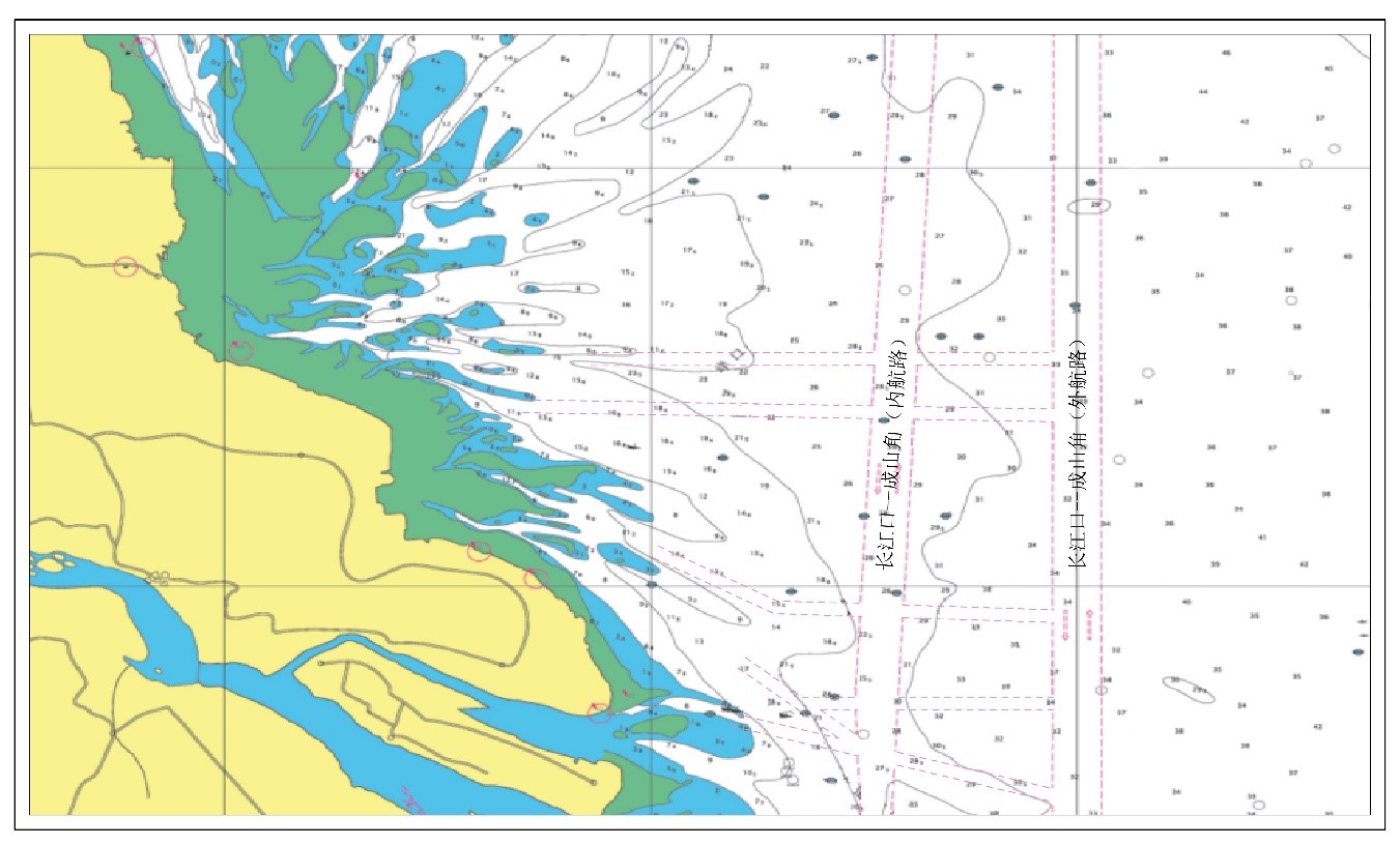
The sketch map of the public routes along the coast of Nantong
The Public Routes along the Coast of Nantong
1. The North Route (2 nautical miles in width) entering/leaving Yangkou Port from the North-South Customary Route (outer route, the same below)
The center line of the route is the connection of the following points:
32°32′07.37″N / 123°03′21.79″E
32°32′05.08″N / 121°51′36.98″E
32°32'14.16"N / 121°45'07.18”E
2. The South Route (2 nautical miles in width) entering/leaving Yangkou Port from the North-South Customary Route
The center line of the route is the connection of the following points:
32°24′02.43″N / 123°03′21.79″E
32°25′26.07″N / 121°42′04.06″E
32°26'29.50″N / 121°40'20.70″E
3. The Middle Route (2 nautical miles in width) entering/leaving Tongzhou Bay from the North-South Customary Route
The center line of the route is the connection of the following points:
31°55′36.06″N / 123°03′21.79″E
31°57′05.16″N / 122°17′34.09″E
32°04′51.91″N / 122°00′42.09″E
4. The South Route (2 nautical miles in width) entering/leaving Tongzhou Bay from the North-South Customary Route
The center line of the public route entering Lvsi, Dongzao and Tongzhou Bay from the north is the connection of the following points:
31°43′29.99″N / 123°03′21.79″E
31°43′29.99″N / 122°21′04.67″E
31°49′13.69″N / 122°12′51.35″E
31°49′58.80″N /122°12′36.80″E
The center line of the public route entering Lvsi, Dongzao and Tongzhou Bay from the south is the connection of the following points:
31°29′00.18″N / 123°03′21.79″E
31°36′39.19″N / 122°30′54.30″E
31°49′13.69″N / 122°12′51.35″E
31°49′58.80″N / 122°12′36.80″E
5. The Public Route (2 nautical miles in width) entering/leaving the seaward channel of Qidong Port at the Yangtze River Estuary from the North-South Customary Route
The center line of the public route is the connection of the following points:
31°29′00.18″N / 123°03′21.79″E
31°41′11.79″N / 122°11′37.76″E
31°41′42.90″N / 122°11′17.30″E
The Main Channels along the Coast of Nantong
1. Yangkou Operation Area
(1) Yangkou Port North Approach Channel (Lanshayang North Waterway Channel)
With a total length of approximately 18.6 kilometers, the channel starts from point A0 (32°32'29.99 "N/121°40'23.89" E) at the entrance of the Lanshayang north waterway in the east, and ends at point B3 (32°33'23.5 "N/121°28'32.83"E) northeast of the LNG terminal in the west. The minimum depth of the channel is -10.6 meters (the local theoretical minimum tide level), with a designed width of 450 meters, which meet the requirements of two-way navigation of 100,000DWT lightened ships and one-way navigation of 267,000 cubic meters LNG ships by tide.
(2) Yangkou Port South Approach Channel (Lanshayang South Waterway Channel)
With a total length of approximately 24.82 kilometers, the channel starts from point A (32°26'29.5 "N/121°40'20.7" E) at the entrance of Lanshayang south waterway channel in the east, and ends at point D (32°30'43.1 "N/121°25'30.2"E) near the Xitaiyangsha south wharf area in the west. The designed water depth of the channel from the entrance of the channel to the Jinniu Island operating area is -11.1 meters, and the designed water depth of the channel from the Jinniu Island operating area to the heavy cargo terminal is -9.2 meters, with a designed width of 400 meters and a navigable width of 300 meters, which meet the requirements of ships of 10,000 DWT navigating to the heavy cargo terminal under all tidal conditions and bulk carriers of 70,000 DWT navigating to the planned Jinniu Island operating area by tide.
2. Lvsi, Sanjiasha, Tongzhou Bay and Haimen Operation Area
(1) Xiaomiaohong Port Approach Channel
(i)With a total length of 53.41 kilometers, the channel starts from point A (31°49'58.8 "N/122°12'36.8" E) of the -18 meters isobath outside the entrance of the Xiaomiaohong Channel in the open sea, and ends at point D (32°04'39.9 "N/121°46'31.7" E) near the Lvsi Datang Power Plant terminal. For the section of the channel where the designed depth is -13.1 meters, the corresponding navigation width of the channel is 218 meters, whereas for the section of the channel where the designed depth is -11.0 meters, the corresponding navigation width is 286 meters. The channel meets the requirements of one-way navigation of 185,000 cubic meters LNG ships and 100,000 DWT bulk carriers by tide, and two-way navigation of 20,000 DWT bulk carriers/general cargo ships under all tidal conditions.
(ii)With a total length of 19.2 kilometers, the channel starts from point D (32°05'45.514 "N/121°44'27.924" E) near the Lvsi Datang Power Plant terminal, and follows the Xiaomiaohong waterway to the starting point G’(32°09'40.7 "N/121°33'31.9" E) of the Sanjiasha South Channel. The total length of the channel is 19.2 kilometers, with a designed depth of -11.7 meters. The navigation width of the outer section of the channel is 246 meters, the navigation width of the entrance section is 263 meters, and the navigation width of the inner section is 228 meters. The channel meets the requirements of one-way navigation of 50,000 DWT bulk carriers by tide, and two-way navigation of 20,000 DWT bulk carriers and general cargo ships under all tidal conditions.
(2) Lvsi Harbour Basin Approach Channel
The channel starts from point D (32°05'09.197 "N/121°37'47.964" E) of the west boundary of berths 8 # -11 # in the west basin of Lvsi harbor basin, and ends at point A (32°05'43.83 "N/121°44'28.64" E) at the intersection point of Xiaomiaohong approach channel. The total length of the channel is 10.9 kilometers, with a designed depth of -12.9 meters and navigation width of 201-256 meters, which meet the requirements of one-way navigation of 100,000 DWT bulk carriers and 100,000 DWT container ships by tide.
(3) Sanjiasha South Channel
The channel starts from point G '(32°09'40.697 "N/121°33'31.915" E) and follows the southwest waterway to point K (32°08'26.781 "N/121°30'17.260" E) on the north side of the Dongzao Port operation area. The total length of the channel is about 6.5 kilometers, with a designed depth of -11.7 meters and a navigation width of 246-327 meters (turning section 246-536 meters), which meet the requirements of one-way navigation of 50,000 DWT bulk carriers by tide and two-way navigation of 20,000 DWT bulk carriers and general cargo ships under all tidal conditions.
3. Qihai Operation Area
Located at the Yangtze River Estuary and with a total length of 26.5 kilometers, the Qidong port seaward channel starts from Qidong buoy 1 # (31°41'42.9 "N/122°11'17.3" E), passes Qidong buoy 10 # (31°42'41.3 "N/121°01'37.3" E) and ends at Qidong buoy 16 # (31°40'49.4 "N/121°54'23.0" E). With a designed depth of 5.2 meters and a navigation width of 300 meters, the channel meets the requirements of two-way navigation of 3,000 DWT bulk carriers and one-way navigation of 80,000 DWT idle oil tankers.
In addition, there are several other channels under planning and construction in Yangkou port, Sanjiasha and Tongzhou Bay operation area.
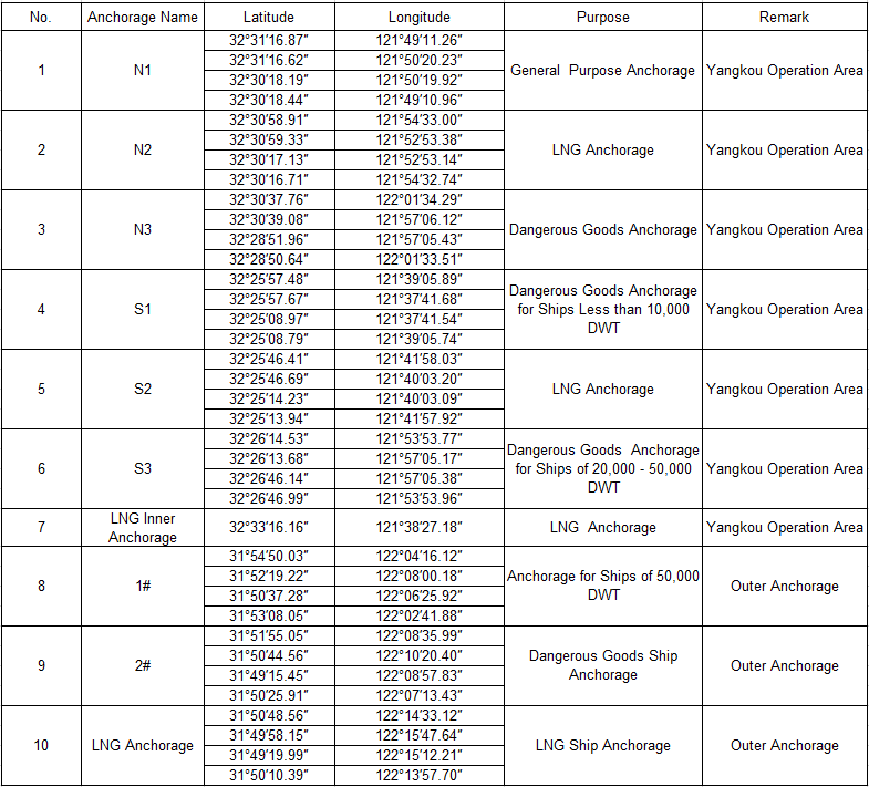
The Main Anchorages along the Coast of Nantong
The following is a list of existing anchorages. In addition, there are several outer anchorages as well as other anchorages with various purposes are also under planning along the coast of Nantong.
Brief Explanation of the Public Routes along the Coast of Nantong by MSA
(1) In any case, the public route is only used as the recommended passage for ships navigating in the coastal waters of Nantong, and is for the reference of ship navigation personnel only. It does not exempt ship navigation personnel from their responsibility for the safe navigation of the ship.
(2) The direction of the turning point on the center line described in the Notice is for the purpose of indicating the route position and direction only, and is not the route and course that recommended for ships to use. It is recommended that ships navigate as close to the right side of the center line as possible.
(3) The route width is the theoretical width. Due to limitations such as natural environment and navigation conditions, the width of a route is limited to the actual width of the navigable waters.
(4) The ship shall reasonably formulate her passage plan according to her characteristics and the real environment of the sea area through which she is navigating, and with reference to the latest nautical charts and publications.
(5) The ships shall strictly comply with the COLREGS, 1972 and the relevant provisions published by the competent authority. When a ship is navigating within the route, attention should be paid to the change of the sounding depth to prevent the ship from grounding accidents. The ship shall navigate with extreme caution when entering, leaving or crossing the route, passing through the dense traffic waters or the intersection waters of the route.
(6) To ensure smooth navigation and prevent collisions and other maritime traffic accidents, ships should avoid mooring, anchoring or operating (including fishing operations) in the waters of the route as much as possible.
Huatai's Suggestions
(1) The announcement and adoption of public routes and main channels along the coast of Nantong provide strong guarantees for ships safely entering and leaving Nantong seaports. It is recommended that when ships navigating in these waters should, as far as possible, give priority to the use of public routes and channels published by the MSA.
(2) The public routes entering and leaving Nantong seaports intersect with the north-south customary route (inner route), and a large number of merchant ships converged in this water area, forming crossing, head-on and other situations. Therefore ships should strictly comply with COLREGS in order to avoid the occurrence of collision accidents when navigating in the public routes in these waters.
(3) It is worth noting that there are a large number of fishing boats operating in these waters, thus ships should proactively take reasonable measures to pass and clear all fishing boats, including their fishing gear and nets.
(4) Due to the influence of natural conditions and surrounding environment, there are numerous shoals in the water area off Nantong seaports. When a ship is navigating in the vicinity of the shoals, particularly in the channel adjacent to the shoals, special attention should be paid to prevent the occurrence of grounding accidents.
source: Huatai Insurance Agency & Consultant Service
source: Huatai Insurance Agency & Consultant Service
The opinions expressed herein are the author's and not necessarily those of The Xinde Marine News.
Please Contact Us at:
media@xindemarine.com