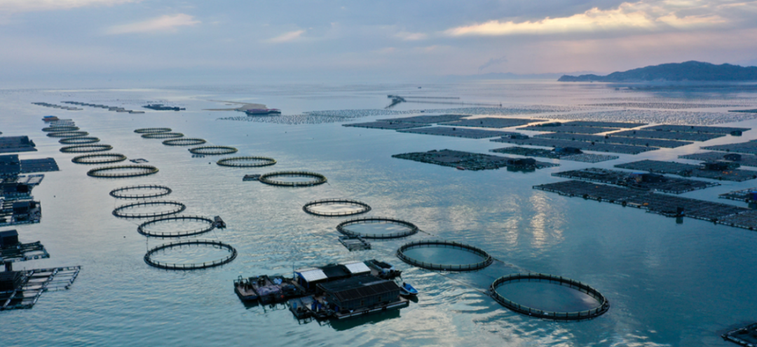
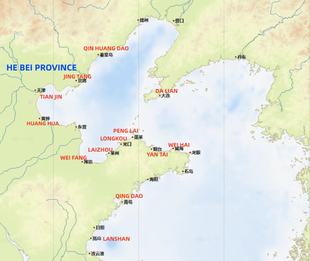
The following figure shows the port distribution of cases regarding ships accidentally entering fishery farms handled by Huatai in the past three years (2020-2022).
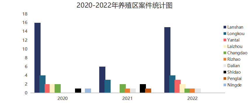
In the above figure, except for Dalian and Ningde, all other ports are under the jurisdiction of Shandong Province. Lanshan Port remains the port with the highest number of cases, falling to 6 in 2021 but rising to 15 in 2022.
Reasons for the High Incidence of Fishery Farm Claims in Lanshan Port
We opine that the high incidence of such cases in Lanshan Port may be related to the following factors:
(1) Compared with other ports, the quantity of fishery farms off Lanshan Port is larger and the distribution is wider.
(2) The fishery farms are located at the junction of Rizhao, Lanshan and Lianyungang Port. The navigation environment for merchant ships and fishing boats is complex, and the maneuverable water area for merchant ships to avoid collision with other ships and fishery farms is severely restricted.
(3) Ships have not marked the scope of fishery farms on the Chart according to the Huatai Circular concerning the distribution of fishery farms and the information provided by the agent in order to make a reasonable navigation plan to avoid the area.
(4) Seafarers are lack of psychological vigilance on the fact that large number of fishery farms and fishing boats exist in these water areas. As the consequence, when emergency situations occur, timely and reasonable measures are not taken to avoid accidents.
(5) The risk of accidentally entering fishery farms increases when entering or leaving the port during night time or under poor visibility circumstances.
Loss Prevention Suggestions
(1) Please note that the geographical scope of the fishery farm is changing constantly, and the coordinates of the fishery farm mentioned in this Circular is for reference only.
(2) If there is a route recommended by the MSA, ships are advised to follow such recommended routes with great caution.
(3) When sailing in the waters near the fishery farms, ships should use visual, hearing and any other available means to maintain a proper lookout, keep close contact with the vessel traffic service center and pilot station, and consider following their suggestions after confirming that the surrounding environment and target waters are safe.
(4) Despite the above suggestions, we remind the Master that the resources and information provided by the vessel traffic service center, pilot station, agent, etc. might be inadequate, the Master has the responsibility and absolute right to decide whether to follow the suggestions provided according to his professional judgment.
(5) It is suggested that the Master, after considering the information provided by the agent and this Circular, plot the geographical scope of the fishery farms on the electronic or paper chart for reference, and develop a comprehensive voyage plan, in order to prevent accidentally entering into the fishery farms.
(6) Try to avoid entering and leaving the above-mentioned ports during night time or under restricted visibility circumstances as far as practicable in view of the shipping schedule, commercial considerations and other relevant conditions.
(7) When ships enter or leave the above ports, prepare engine and both anchors in advance, adopt safe speed, take into due consideration of enhancing bridge manpower, posting additional lookouts on the bridge and forecastle.
(8) In the event of an unfortunate accident relating to fishery farms, please report to the vessel traffic service center, the local agent and the ship management company in time and contact Huatai as soon as possible. Our timely intervention will be more conducive to fixing relevant favorable evidence and safeguarding the rights and interests of Owners.
Attachments: Distribution and Coordinates of Fishery Farms
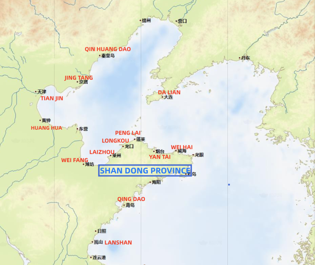
1. Distribution of Fishery Farms along the Coast of Shandong Province
1.1. Fishery Farms off Laizhou Port
1.2. Fishery Farms off Yantai Port
1.3. Fishery Farms off Longkou Port
1.4. Fishery Farms off Penglai Port
1.5. Fishery Farms off Lanshan Port
2. Distribution of Fishery Farms along the Coast of Liaoning Province
2.1. Fishery Farms off Dalian Port
3. Distribution of Fishery Farms along the Coast of Fujian Province
3.1. Fishery Farms near Ningde
3.2. Fishery Farms near Nanri Island
4. Distribution of Fishery Farms along the Coast of Hebei Province
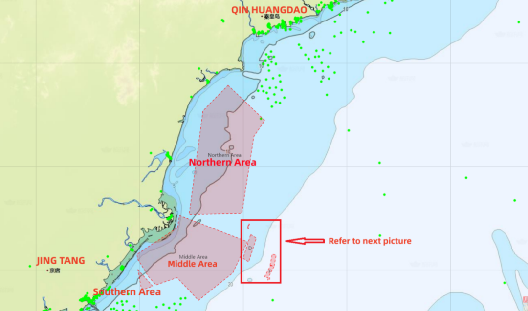
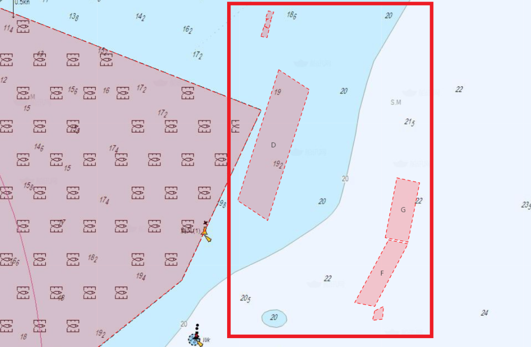
4.1 Fishery Farms off Jingtang Port and Qinhuangdao Port
4.2 Fishery Farms off Huanghua Port
1. Distribution of Fishery Farms along the Coast of Shandong Province
 1.1 Fishery Farms off Laizhou Port
Area S1:
1. 37°39.267′N 119°41.152′E
2. 37°39.266′N 119°40.350′E
3. 37°38.564′N 119°40.349′E
4. 37°38.565′N 119°41.158′E
1. 37°44.251′N 119°46.158′E
2. 37°44.263′N 119°47.076′E
3. 37°44.964′N 119°47.086′E
4. 37°44.962′N 119°46.152′E
1. 37°39.882′N 119°41.157′E
2. 37°39.880′N 119°39.543′E
3. 37°39.319′N 119°39.513′E
4. 37°39.300′N 119°41.131′E
1. 37°44.026′N 119°45.152′E
2. 37°44.029′N 119°45.993′E
3. 37°44.863′N 119°46.004′E
4. 37°44.858′N 119°45.165′E
1. 37°43.550′N 119°43.800′E
2. 37°42.730′N 119°44.000′E
3. 37°42.730′N 119°42.160′E
4. 37°43.545′N 119°42.000′E
1. 37°44.623′N 119°42.939′E
2. 37°44.629′N 119°45.003′E
3. 37°44.800′N 119°45.001′E
4. 37°44.810′N 119°43.041′E
1. 37°47.770′N 119° 49.700′E
2. 37°47.770′N 119° 48.800′E
3. 37°47.380′N 119° 48.800′E
4. 37°47.380′N 119° 49.700′E
1. 37°47.380′N 119°49.700′E
2. 37°47.020′N 119°49.700′E
3. 37°47.020′N 119°48.800′E
4. 37°47.380′N 119°48.800′E
1. 37°48.400′N 119°49.700′E
2. 37°48.400′N 119°48.700′E
3. 37°47.790′N 119°48.700′E
4. 37°47.790′N 119°49.700′E
1. 37°47.000′N 119°48.500′E
2. 37°47.000′N 119°49.850′E
3. 37°46.500′N 119°49.850′E
4. 37°46.500′N 119°48.500′E
1. 37°46.50′N 119°47.30′E
2. 37°46.50′N 119°49.85′E
3. 37°45.70′N 119°49.85′E
4. 37°45.70′N 119°47.30′E
1. 37°45.69′N 119°47.30′E
2. 37°45.69′N 119°49.85′E
3. 37°45.10′N 119°49.85′E
4. 37°45.10′N 119°47.30′E
1. 37°44.28′N 119°49.12′E
2. 37°45.08′N 119°49.12′E
3. 37°45.08′N 119°47.80′E
4. 37°44.28′N 119°47.80′E
1. 37°34.850′N 119°43.00′E
2. 37°36.265′N 119°43.00′E
3. 37°36.265′N 119°43.50′E
4. 37°34.850′N 119°43.50′E
1. 37°39.45′N 119°42.23′E
2. 37°38.84′N 119°42.23′E
3. 37°38.84′N 119°42.84′E
4. 37°39.45′N 119°42.84′E
1. 37°39.30′N 119°41.20′E
2. 37°38.56′N 119°41.20′E
3. 37°38.56′N 119°41.80′E
4. 37°39.30′N 119°41.80′E
1. 37°41.18′N 119°43 48′E
2. 37°40.85′N 119°43 48′E
3. 37°40.18′N 119°42.05′E
4. 37°40.85′N 119°42.05′E
1. 37°39.88′N 119°41.26′E
2. 37°39.34′N 119°41.26′E
3. 37°39.34′N 119°42.06′E
4. 37°39.88′N 119°42.06′E
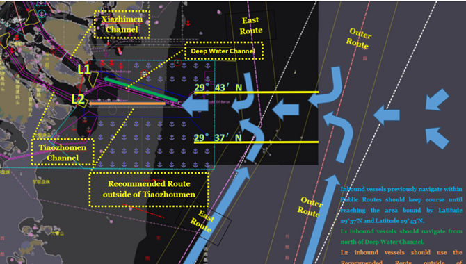
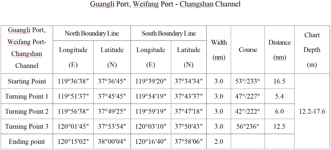
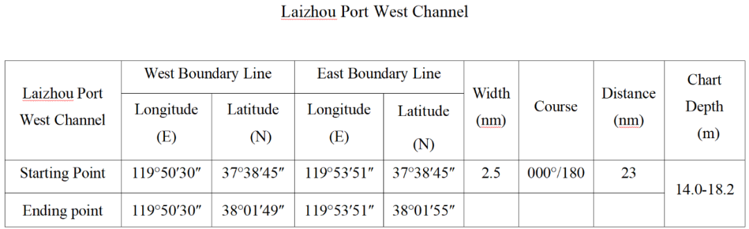
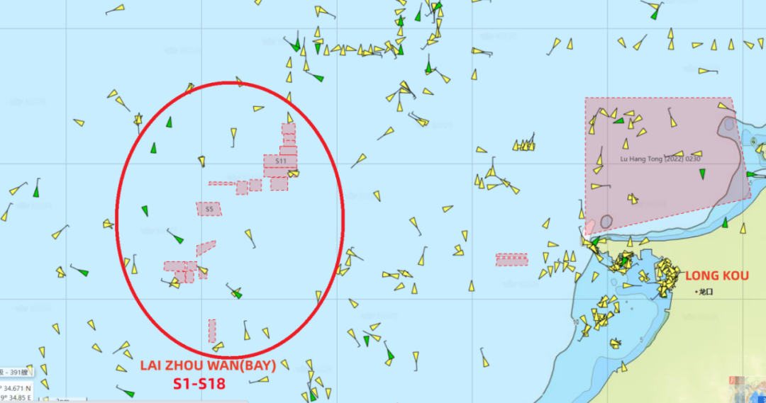
According to Huatai’s experience in the handling of such cases, there are multiple fishery farms in the waters of Laizhou Bay, including but not limited to the above-mentioned fishery farms, and some of them have even expanded to the recommended routes. West-bound ships sailing out of Changshan Channel to Weifang Port, or sailing from Penglai/Longkou/other northern Ports to Weifang Port, are exposed to high risks of entering the fishery farms off Laizhou. Ships are suggested to proceed along following recommended routes in order to avoid entering fishery farms.
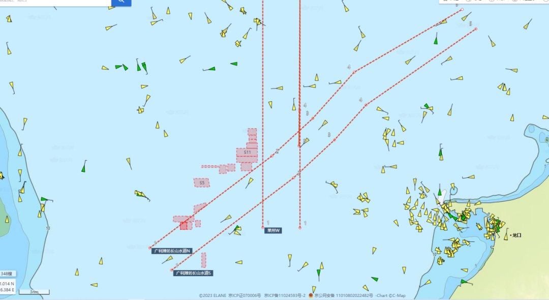
(1) The fishery farms in the above chart are just small parts of the fishery farms in that area which are obtained during our case handling, and most of them are not plotted on the chart due to limited information available.
(2) It is noted that any claims for damage to fishery farms within the recommended channels are usually not upheld by the local authorities.
1.2 Fishery Farms off Yantai Port
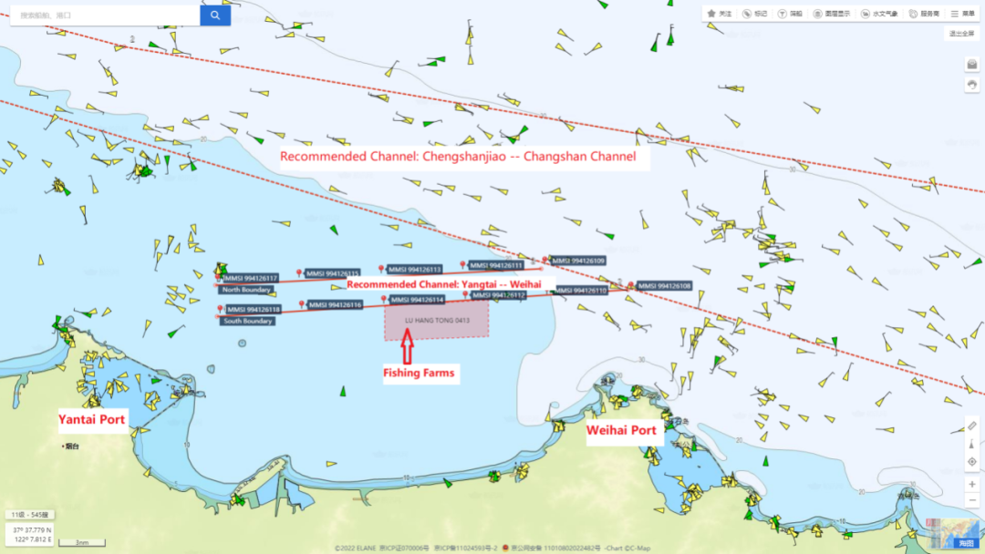
In order to avoid fishery farm damage cases off Longkou Port, Yantai MSA has issued series of Navigation Notices regarding the information of fishery farms within their jurisdiction on their website, and the latest one is (Lu Hang Tong [2022] 0413).
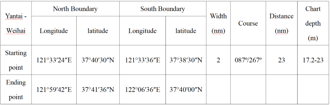
Fishery farm range in the sea area south of Yantai - Weihai public Channel
Fishery farms are found within the sea area connected by the following four coordinates:
The distance between the north boundary of the fishery farm area and the south boundary of the channel is 200m, and the ships passing by should strengthen lookout and navigate cautiously to avoid entering those farms.
This Notice is only used as navigation safety information for passing ships.
Ships are suggested to proceed along following MSA recommended route in order to avoid entering fishery farms.
In addition, in order to give adequate warning to ships to avoid passing through the fishery farms, the MSA established 11 virtual AIS Marks on the above-mentioned channel from Yantai to Weihai. According to the MSA Navigation Warning (Lu Hang Jing 0367) published on Aug. 08, 2022:
YELLOW SEA, ELEVEN VIRTUAL AIS MARKS ESTABLISHED ON THE ROUTE FROM YANTAI TO WEIHAI.
YW ROUTE NO.1(37-40.00N 122-06.60E), MMSI 994126108.
YW ROUTE NO.2(37-41.60N 121-59.70E), MMSI 994126109.
YW ROUTE NO.3(37-39.71N 121-59.85E), MMSI 994126110.
YW ROUTE NO.4(37-41.33N 121-53.12E), MMSI 994126111.
YW ROUTE NO.5(37-39.42N 121-53.31E), MMSI 994126112.
YW ROUTE NO.6(37-41.06N 121-46.55E), MMSI 994126113.
YW ROUTE NO.7(37-39.12N 121-46.74E), MMSI 994126114.
YW ROUTE NO.8(37-40.78N 121-39.97E), MMSI 994126115.
YW ROUTE NO.9(37-38.81N 121-40.17E), MMSI 994126116.
YW ROUTE NO.10(37-40.50N 121-33.40E), MMSI 994126117.
YW ROUTE NO.11(37-38.50N 121-33.60E), MMSI 994126118.
UNQUOTE
Lu Hang Tong〔2022〕0413 and the MSA recommended channel (with 11 virtual AIS mark)
Please Note:
There are some unidentified fishery farms that are not included in the above navigation notice. The duty officer should keep a sharp lookout during the navigation in that sea area.
1.3 Fishery Farms off Longkou Port
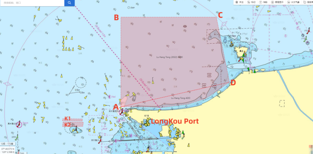
In order to avoid fishery farm damage cases off Longkou Port, the MSA issued a Navigation Notice (Lu Hang Tong [2022] 0230) on the information of fishery farms in the sea area enclosed by the following four coordinates and the coastline:
A:37°41′30″N, 120°12′20″E;
B:37°50′00″N, 120°12′20″E;
C:37°50′00″N, 120°23′42″E;
D:37°43′50″N, 120°25′16″E。
In the Navigation Notice, the MSA points out the following precautions:
(1) The Fishery farms boundary changes with seasons, and ships passing by should strengthen lookout and navigate cautiously to avoid passing through those farms.
(2) This Notice is only used as navigation safety information for passing ships.
However, there are still some unidentified fishery farms that are not included in the above navigation notice (such as K1 and K2 two unlicensed fishery farms).
1. 37° 40.183′N 120° 05.3641′E
2. 37° 40.3809′N 120° 05.4012′E
3. 37° 40.3510′N 120° 07.7620′E
4. 37° 40.1509′N 120° 07.7339′E
1. 37° 40.076′N 120° 05.460′E
2. 37° 40.057′N 120° 07.860′E
3. 37° 39.646′N 120° 07.801′E
4. 37° 39.629′N 120° 05.365′E
1.4 Fishery Farms off Penglai Port
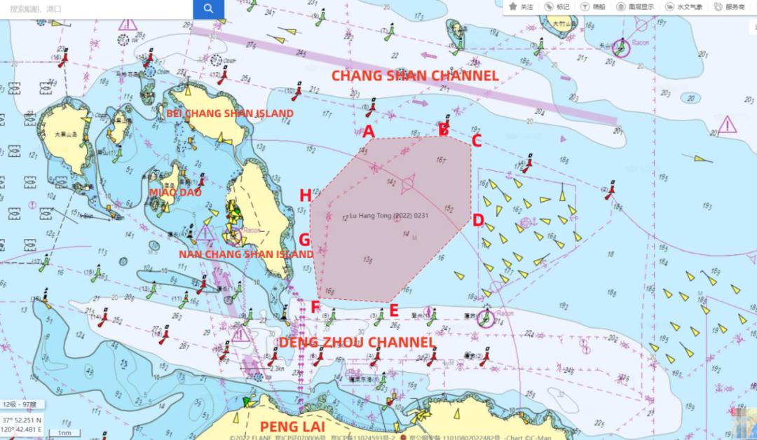
In order to avoid fishery farm damage cases off Penglai Port, the MSA issued a Navigation Notice on the information of fishery farms in the sea area enclosed by the following coordinates:
A:37°57′54″N, 120°48′48″E
B:37°58′00″N, 120°51′48″E
C:37°57′42″N, 120°52′42″E
D:37°55′24″N, 120°52′42″E
E:37°52′48″N, 120°49′30″E
F:37°52′56″N, 120°46′42″E
G:37°55′00″N, 120°46′22″E
H:37°55′53″N, 120°46′22″E
In the Navigation Notice, the MSA points out the following precautions:
(1) The Fishery farms boundary changes with seasons, and the ships passing by should strengthen lookout and navigate cautiously to avoid passing through those farms.
(2) This Notice is only used as navigation safety information for passing ships.
There are some unidentified fishery farms that are not included in the above navigation notice. The duty officer should keep a sharp lookout during the navigation in that sea area.
1.5 Fishery Farms off Lanshan Port
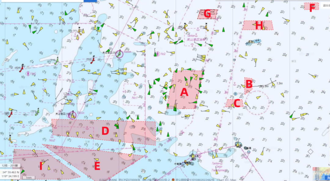
The geographical scope of the fishery farm off Lanshan Port is as follows:
35°06’12.00’’N, 119°50’16.00’’E
35°03’18.00’’N, 119°49’28.00’’E
35°03’18.00’’N, 119°46’48.00’’E
35°06’12.00’’N, 119°47’30.00’’E
35°05′41.18″N, 119°54′03.73″E
35°04′21.77″N, 119°54′03.82″E
35°04′46.97″N, 119°54′45.81″E
35°05′35.97″N, 119°54′45.75″E
35°04′01.06″N, 119°52′29.91″E
35°03′26.77″N, 119°52′15.68″E
35°03′26.87″N, 119°53′56.63″E
35°04′01.14″N, 119°53′49.95″E
35°02’ 30.00’’ N, 119°36’ 11.0’’E
35°02’ 18.00’’ N, 119°45’ 48.0’’E
35°00’30.00’’N, 119°45’48.00’’E
35°01’18.00’’N, 119°36’18.00’’E
35°00’36.00’’N, 119°35’18.00’’E
34°59’42.00’’N, 119°44’48.00’’E
34°57’30.00’’N, 119°40’42.00’’E
35°11’23.43’’N, 119°59’36.03’’E
35°10’52.35’’N, 119°59’36.03’’E
35°10’52.34’’N, 120°00’54.73’’E
35°11’23.43’’N, 120°00’54.74’’E
35°10’ 52.40’’ N, 119°49’ 58.07’’E
35°10’ 10.63’’ N, 119°49’42.15’’E
35°10’ 10.75’’ N, 119°51’20.11’’E
35°10’ 52.34’’ N, 119°51’32.20’’E
35-10’01.66’’N, 119-54’03.38’’E
35-09’19.73’’N, 119-53’52.84’’E
35-09’19.65’’N, 119-56’42.48’’E
35-10’01.58’’N, 119-56’32.59’’E
35°00.21’ N, 119°32.72’ E
35°00.10’ N, 119°35.48’ E
34°58.10’ N, 119°38.87’ E
34°57.91’ N, 119°37.79’ E
34°57.89’ N, 119°32.50’ E
2. Distribution of Fishery Farms along the Coast of Liaoning Province
2.1 Fishery Farms off Dalian Port
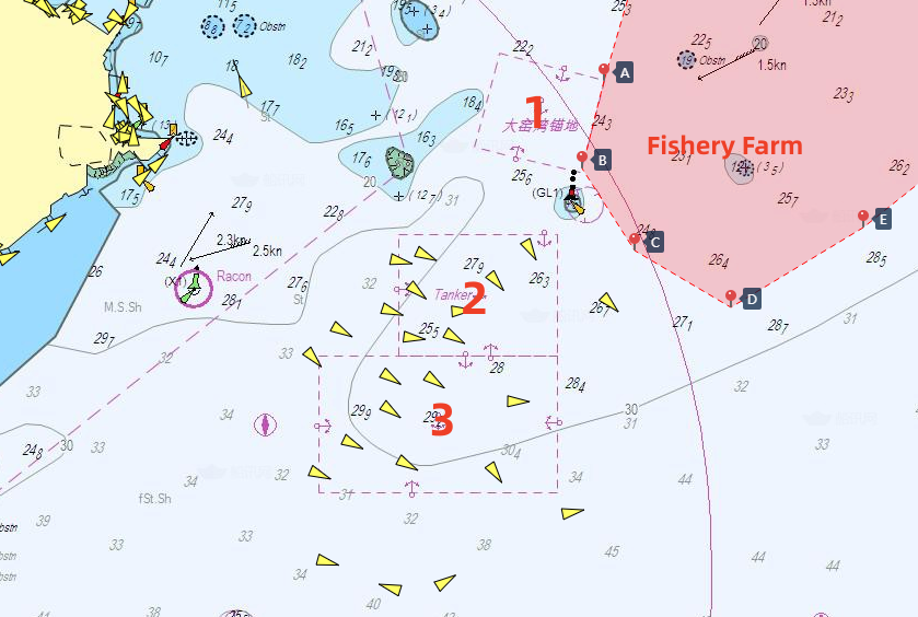
We have marked the three anchorages of Dalian Xingang as 1, 2, and 3 respectively with the following explanation, and the approximate location of the fishery farms are also indicated in the above figure.
(1) Dayaowan Anchorage: It has almost been abandoned, and usually no ships anchor at this anchorage.
(2) Tanker anchorage: Arriving oil tankers normally anchor at this anchorage in accordance with the instructions of Dalian VTS.
(3) Cargo Ship Anchorage: Ships other than oil tankers normally anchor at this anchorage in accordance with VTS instructions.
Fishery farms off Dalian Port mainly concentrated in the northeast of the Dayaowan and Tanker anchorage. Due to its close proximity to the anchorage, cases of ships accidentally entering the fishery farm occur from time to time. In recent years, the area of the fishery farms has been continuously expanding, and the specific areas have also been changing constantly, thus the boundary of the fishery farms mentioned in this Circular is for reference only. Considering that it is normal for ships on international voyage entering the anchorage from the south side, those ships are safe as long as they do not cross the lines joining by the following coordinates to the north.
A 38°59.063′N, 122°02.923′E
B 38°57.775′N, 122°02.518′E
C 38°56.569′N, 122°03.503′E
D 38°55.731′N, 122°05.321′E
E 38°56.903′N, 122°07.820′E
3. Distribution of Fishery Farms along the Coast of Fujian Province
 3.1 Fishery Farms near Ningde
The geographical scope of the fishery farms:
A 26-44.55′N, 119-38.05′E
B 26-45.85′N, 119-47.32′E
C 26-35.50′N, 119-50.07′E
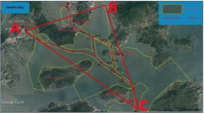
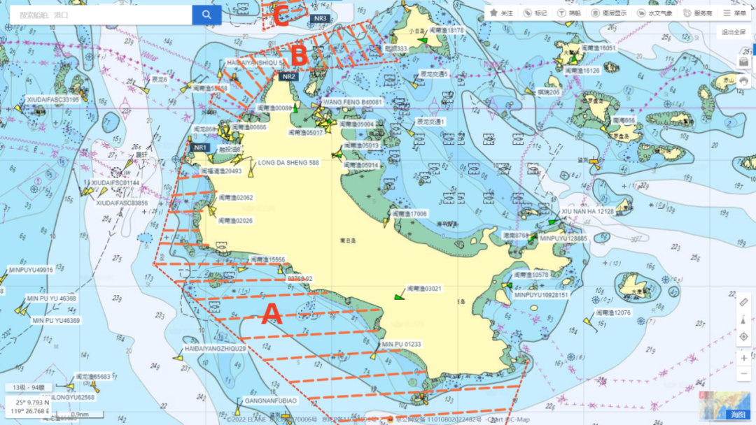
The red dashed line in the above picture represents the buoyed channels. There are dense fishery farms distributed near the channel of Sansha Bay (marked by yellow dashed lines in the picture), and some of them are even distributed within the buoyed channels.
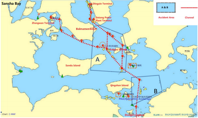
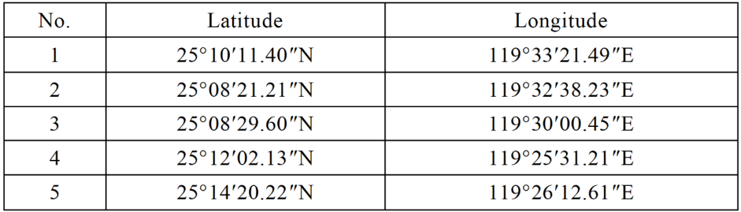
According to Huatai’s experience in the handling of such cases in the Sansha Bay, ships accidentally entering the fishery farm mainly occurred in two areas.
Area A: the channel near Baipao Island
and Area B: the east channel of Qingshan Island (as shown in the above figure).
Several reasons that might attribute to occurrence of the cases of ship accidentally entering fishery farms:
(1) Currents in the above two channels are extremely strong, with a velocity of 3-5 knots. The rudder effect is poor when ships sail with the current.
(2) The navigable width of the channel is very narrow, whereas the turning angle is large, making it extremely difficult for ship manoeuvring.
(3) A large number of fishing boats navigate within or cross the channel, as a result, the available room for avoiding collision or entering fishery farms is limited.
(4) Dense fishery farms are distributed around and even within the channel. Ships are prone to enter the fishery farm, if they fail to return to the main channel in a timely manner after giving way to other ships.
The geographical scope of the above-mentioned fishery farms (A)
39°46.206’N, 119°’28.744’E
39°40.711’N, 119°’36.201’E
39°38.203’N, 119°’ 34.038’E
39°26.017’N, 119°’ 31.535’E
39°25.809’N, 119°’ 20.844’E
39°42.199’N, 119°’23.656’E
39° 23.764’N, 119°18.403’E
39°25.713’N, 119°18.897’E
39°21.526’N, 119°32.678’E
39°16.629’N, 119°29.753’E
39°12.272’N, 119°22.749’E
39°15.829’N, 119°18.321’E
39°14.676’N, 119°14.098’E
39°15.965’N, 119°12.594’E
39°18.878’N, 119°10.277’E
39°19.582’N, 119°10.184’E
39°17.134’N, 119°10.338’E
39°14.491’N, 119°13.459’E
39°13.931’N, 119°11.451’E
39°14.371’N, 119°10.998’E
Scattered fishery farms outside the above-mentioned areas (B)
 4.2 Fishery Farms off Huanghua Port
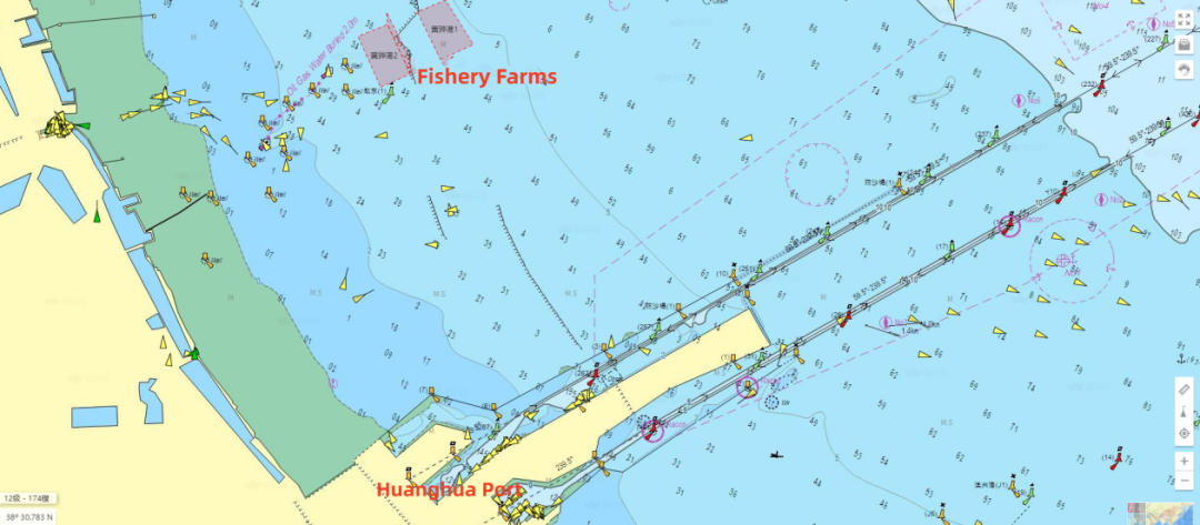
The Huanghua MSA has announced the geographical location of the following 3 fishery farms
A.38°30′ 58.785″N, 117°50′ 09.520″E
B.38°31′22.311″N, 117°51′ 13.607″E
C.38°32′31.321″N, 117°50′ 19.209″E
D.38°32′12.661″N, 117°49′ 23.219″E
A.38°30′ 15.713″N, 117°48′ 12.299″E
B.38°30′36.743″N, 117°49′ 09.518″E
C.38°31′53.501″N, 117°48′ 25.760″E
D.38°31′34.229″N, 117°47′ 27.998″E
A.38°30′ 36.743″N, 117°49′ 09.518″E
B.38°30′58.785″N, 117°49′ 09.520″E
C.38°32′12.661″N, 117°48′ 23.219″E
D.38°31′53.501″N, 117°48′ 25.760″E
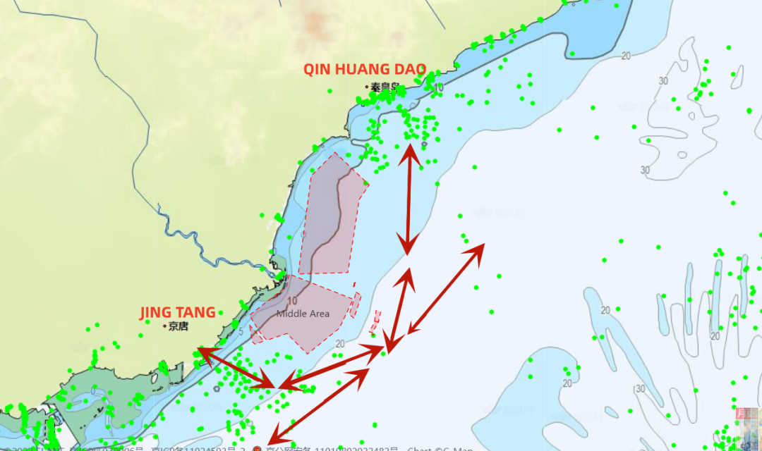
According to Huatai’s experience in the handling of such cases in recent years, most of the fishery farms along the coast of Hebei Province are located between Jingtang and Qinhuangdao Port, as well as in the waters near Huanghua Port. Ships navigating between Jingtang/Tianjin/Huanghua Port and Qinhuangdao/Jinzhou Port are suggested to plan their routes away from the coast to avoid accidentally entering the fishery farms.
Source:
HUATAI
The opinions expressed herein are the author's and not necessarily those of The Xinde Marine News.
Please Contact Us at:
media@xindemarine.com


.gif)


 China’s First Bulk Bunkering of Domestic Green Me
  Rotterdam and Singapore Strengthen Collaboration on
  MPA and CMA CGM Sign MoU to Enhance Sustainable Shi
  China's Ports Surge Ahead: Major Container Terminal
  Port of Hamburg: Growth in container throughput and
  EPS and SPDB Financial Leasing sign financing agree