Navigating a ship has always involved risks, but it is near the shore and in ports where the danger is greatest. A new analysis based on Gard claims data reveals where vessels are most likely to be involved in groundings or collisions.
Human error is usually listed as the root cause of most collisions and groundings but claims data from Gard clearly shows that other factors also play a key role.
Back in 2021, Gard in collaboration with Windward and Lloyd’s List Intelligence mapped the global incident hot spots and showed that some geographic areas are much more prone to navigation accidents than others. Now, two years later, we have developed our own heat maps, using AIS and our own claims data, and can give a more granular overview of which areas and locations to be aware of.
Ports: some are safer than others
Our analysis of claims data from the ten largest container ports in Asia, Europe, and the Americas respectively, show that there are significant variations when it comes to the likelihood of navigational accidents in and around the port. Some ports are riskier than others. Interestingly, we find ports with a higher-than-average frequency of claims in all parts of the world. East Asia, Northern Europe, and North America are all represented on our “top five” list, and Middle East, Southern Europe, and Latin America follow closely. Gard created this analysis by examining the number of significant claims (above USD $100k) cross-referenced against the number of hours vessels covered by Gard spend in the same geographical area. All data from 2015-22.
Large ports by frequency of navigational accidents

Red areas indicate areas with high incident frequency, yellow indicates medium frequency, while green is low frequency.
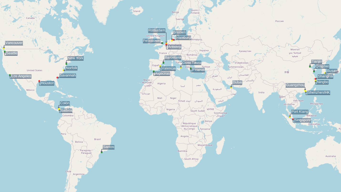
Same map as above, but including port names.
There may be several reasons why some ports are riskier than others. One common factor seems to be the entrance to the port area. Houston, Antwerp, and Savannah are far from each other, but all have a rather difficult entrance involving rivers and/or canals. Meanwhile, Los Angeles, Felixstove, and Qingdao all have ports that are located closer to the open sea, which means less difficult navigation.
More research is required to identify ways to make a port entrance safer. Other potential port risk factors that could be investigated include:
·Traffic separation schemes
·Depth and width of navigable waters
·Effectiveness of Vessel Information and Traffic Systems (VTIS)
·Pilot training and navigation experience in the area
·Currents, tidal variations, exposure to weather elements and other geographical factors.
Beware of rivers, straits, and canals
While we see that incident hotspots are generally spread out across the globe, very few incidents happen in open sea.
Narrow waters are particularly incident-prone, especially rivers and estuaries in South America and North America. The busiest rivers, like the Paraná, Mississippi, and St.Lawrence, are all among the most high-risk areas in the world. Furthermore, we find smaller clusters of claims around less trafficked areas like the Orinoco, Essequibo and Guayas rivers.
Straits are another high-incident waterway. The Bosporus Strait in Turkey stands out, and there are several hot spots around the straits in Southeast Asia. We see a higher number of incidents in the Malacca, but the most exposed strait during the period analyzed has been the Karimata, an area Gard has done several case studies on also before. We also see high frequencies in the area of Chittagong, another high-risk location, perhaps related to local scrapping activity.
Canals are a third category of narrow areas where we find a higher risk. There has been a number of well-known cases in the Suez Canal. Another problematic area is the Kiel Canal, possibly in combination with the lower parts of the Elbe River.
Vessel behaviour makes a difference
In addition to geographical factors, we have also examined whether certain types of vessel behaviour increase the risk of incidents. Gard used AIS movement data to evaluate the different types of behaviours that have historically led to navigation incidents. Claims frequency is divided into subgroups of claims of the same type, such as groundings or collisions. The analysis also included static factors like type, size, and age of a vessel to examine the factors that may have an impact both on claims and behavioural data. A VLCC would normally on average travel more nautical miles in a year compared to smaller tankers. This way we can avoid “comparing apples with oranges”.
The following are some of the high-risk behaviours which we found to correlate with groundings:
·Speed: We studied the vessel’s maximum observable speed (AIS speed) over a period of time and found that the higher the speed relative to the vessel’s service speed, the higher the likelihood of a grounding.
·Proportion of time in median speed: In essence, the fewer speed fluctuations, the lower the risk of grounding. A steady speed during the voyage tends to reduce the risk of grounding.
·River traffic: As indicated above, the more time a vessel spends in rivers, the more likely it is to have an incident. This would be rather obvious to a mariner, but there is a strong likelihood of a grounding when navigating in rivers.
·Number of port calls: the higher number of port calls, the higher the risk of grounding. This goes for all ports, not just the hot spots.
·Number of unique port calls: The higher the number of different ports visited, the higher the likelihood of a claim. The risk increases when calling at a port not previously visited or not frequently visited by the vessel and this can be attributed to the lack of familiarity that the bridge team would experience during a port visit.
For collisions, we found the following key risk factors:
·Calls to large ports: The higher the traffic in a port, the higher the risk. Interestingly, we find that this factor is mostly important for third-party liability.
·Time anchored: The longer a vessel stays at anchor, the higher the risk of a collision, as many vessels are anchored around busy traffic lanes.
·Mileage: The higher the total nautical miles travelled by a vessel throughout a year, the lower the risk of collision. In other words: the more time at sea, the less the likelihood of an incident.
·Again, speed: Just as for groundings, the higher the speed, the higher the likelihood of a collision. For collisions, we find that the service speed and most common (typical) speed are more useful factors than the max speed.
At first glance, of course, some of these bullet points might seem obvious – more traffic and higher speeds will clearly increase the likelihood of an accident. Some of the issues listed above are also difficult to do much about, at least for the bridge team: where the vessel trades and the number of port calls are primarily commercial decisions.
That being said, several of the risk factors can be influenced. Fewer accelerations, steady speed, increased vigilance, and better preparations before entering a new port have the potential to significantly reduce the risk of something going wrong.
Key takeaways for mariners and shipowners
Improved voyage planning
Navigation audits and risk assessments do not always take geographical factors into account. The same goes for the risks associated with a certain trade pattern or vessel behaviour. Understanding global hotspots and typical risk behaviours will provide a better and more comprehensive picture of the risk. Ideally, these factors should be assessed and discussed with the bridge team during the voyage planning. Increased knowledge and awareness would help members manage and reduce the risk.
Improved safety of navigation
Safety of navigation largely lies with the bridge team, with support from the engineering team. The support role of the onshore team is seldom recognised when it comes to planning a safe voyage. In Gard, the highest number of loss prevention queries from our members and clients relate to port and geographical risks. A global navigation risk picture, supported by data, could provide onshore operators with relevant information to support their vessel bridge teams.
Improved investigation of incidents
The majority of investigations into navigation incidents indicate “human error” as the root cause of the incident. It is rare that an investigator tries to reconstruct the incident to fully understand the circumstances. This implies that investigations can entirely miss the underlying and dynamic problems of navigating a vessel in a particular environment.
As an example, when a vessel is on a tight port rotation, we recommend that our members and clients consider the heightened risks of a navigation incident and advise their bridge team accordingly. Similarly, when the vessel is calling a congested port or a new port, heightened diligence and preparation is required. And for those making commercial decisions on shore, it is crucial to factor in the safety aspects in all operations.
This article was first published in Maritime Risk International.
Source: Gard
Source: Gard
The opinions expressed herein are the author's and not necessarily those of The Xinde Marine News.
Please Contact Us at:
media@xindemarine.com