Duringthe process of using ECDIS installed onboard, there are lots of questions and doubts raised by the mariner, this may cause confuse when PSC inspection and vetting are being carried out on the ship. Especially, when ECDIS software upgrade to PL4.0, a new function- route filter appears. The mariner and PSC inspector can pick up one route or use present route by this function, to check whether all the charts relate the route have been ordered or not, also can show charts status. This function can easily let the mariner to order the charts without any missing, but may cause some unnecessary charts to be ordered, like same usage band charts ordered, route only using a corner of the charts, etc. Please be noted that normally the charts ordered onboard by using chart software(Chartco, E-navigator, voyager, gateway, etc.), during charts ordered, the mariner will select the charts by different purposes as per company policy, it is unnecessary to order all the chart relate the route due to the same reason as above. But the problem is, some PSC inspectors know this route filter function and want to use this function to check the charts ordered. when using this function to check the charts, they can easily find some charts (unnecessary charts) were not ordered, and our officer also don’t know how to explain this situation to the inspector, hence it is quite easy to get deficiency from this.
Some company try to avoid this situation, hence make the decision that to order all the charts, but the additional fee will be raised. How to order the charts correctly, what is the standard? what request by the regulation? the mariner, the company, the PSC and FSC may have different interpretations. With regard to this condition, I’d like to present my comments for your good reference and correction.
First,let’s refer the ECDIS requirements, which list in the chapter V of SOLAS convention.
Regulation 19 Carriage requirements for shipborne navigational systems and equipment
2.1 All ships, irrespective of size, shall have:
.4 nautical charts and nautical publications to plan and display the ship’s route for the intended voyage and to plot and monitor positions throughout the voyage; an electronic chart display and information system (ECDIS) may be accepted as meeting the chart carriage requirements of this subparagraph;
Regulation 27
Nautical charts and nautical publications, such as sailing directions, lists of lights, notices to mariners, tide tables and all other nautical publications necessary for the intended voyage, shall be adequate and up to date.
Regulation 34 Safe navigation and avoidance of dangerous situations
1 Prior to proceeding to sea, the master shall ensure that the intended voyage has been planned using the appropriate nautical charts and nautical publications for the area concerned, taking into account the guidelines and recommendations developed by the Organization. ①
2 The voyage plan shall identify a route which:
.1 takes into account any relevant ships’ routing systems;
.2 ensures sufficient sea room for the safe passage of the ship throughout the voyage;
.3 anticipates all known navigational hazards and adverse weather conditions; and
.4 takes into account the marine environmental protection measures that apply, and avoids, as far as possible, actions and activities which could cause damage to the environment.
①Refer to the Guidelines for voyage planning adopted by the Organization by resolution A.893(21).
According to the Annex of RESOLUTION A.893(21) GUIDELINES FOR VOYAGE PLANNING, GUIDELINES FOR VOYAGE PLANNING,
2 Appraisal;
2.1.5 appropriate scale, accurate and up-to-date charts to be used for the intended voyage or passage, as well as any relevant permanent or temporary notices to mariners and existing radio navigational warnings.
Please be noted that above not mention the ships must carry
all nautical charts for the intended voyage. Just only point out the charts may be appropriate scale, accurate and up-to-date.
According to IMO MSC.1/Circ.1503/Rev.1,ECDIS – GUIDANCE FOR GOOD PRACTIC,A CHART CARRIAGE REQUIREMENT OF SOLAS,item 8, In accordance with SOLAS regulation V/19.2.1.4, ships must carry
all nautical charts
necessary for the intended voyage.
Please take caution that the guidance description is different with regulation 19 of SOALS Chapter V regarding the chart selection and using onboard. They mentioned all necessary chart but not all the chart as some person think of.
Accordingthe SOLAS and IMO A893(21) resolution requirement, we can draw the conclusion that, the charts for intend voyage must be adequate, appropriate scale ,accurate and up-to-date, but don’t mention that all the charts relate route needed for purchase. But can cause the mariner and port authority misunderstood and confused, they may make wrong decision and judgment,and also make additional cost for the charts.
During the process of application, ENCs are assigned a compilation scale based on the nature of the source data upon which they are based. They are also allocated to a navigational purpose band related to this. This is analogous to a series of paper chart covering the same area, ranging from “small scale charts” to “larger scale plans”. As shown in the table below there are six navigational purpose bands (scale ranges are indicative only). An ECDIS chart, also known as an chart unit or an chart cell, consists of 8 digit letters and numbers. The first two of them are and are country code, like C1 is for CNHO, C2 for HONGKONG MARDEP, CN for China MSA. The third number of the graph must be a number from 1 to 6. This number represents usage band, there are 1. Overview, 2. General, 3. Coastal, 4. Approach, 5. Harbour, 6. Berthing, each usage bandhave their own range of scales.
The usage scale range as follow:
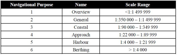
The purpose of each usage band as follow.
1. Overview for planning and oceanic crossing
2. General for navigating oceans, approaching coasts and route planning
3. Coastal for navigating along the coastline, either inshore or offshore
4. Approach for navigating the approaches to ports or major channels or through intricate or congested waters
5. Harbour for navigating within ports, harbour, bays, rivers and canals for anchorages
6. Berthing detailed to aid berthing
The practicality and applicability need to be fully considered for the adequate and appropriate scale charts proposed in the requirements of the rules.It is obviously wrong thatmany companies and some officers even think that as long as they are equipped with the maximum scale chart of the route, they can meet all the requirements and keep safe navigation. It is necessary to equip the route with a maximum scale charts as per requirements. At the same time, we also need consider that vessel may deviation or encounter other unforeseen situations. Thus, we need other scale charts for this issue, but not all charts related to the route need to be equipped. Some scales of the chartarerepetitive and superimposed.
Now I will use the ADC software to do a demonstration and explanation, the route is simply selected from Tianjin to the CJK.
How to usethe ADC software to design the route will not be described in detail here. Many other software features are even more powerful than this. It just simply enters the departure port and the destination port, and the recommended route will come out automatically.
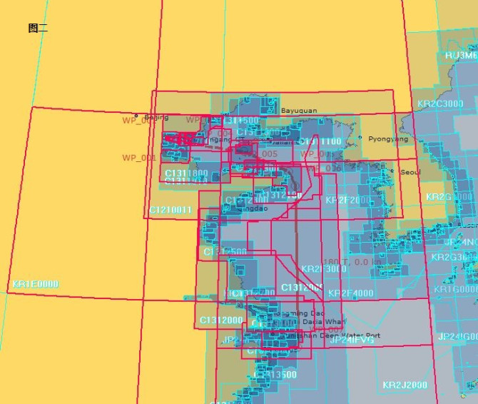
After the route is determined, it is only necessary to add the route to the baskets or similar function menu. All the charts of various scales related to it on the route will be displayed (Figure 2). At this time, the displayed charts are placed in the baskets or purchasing functions. The chart list will come out or form a document (Figure 3).
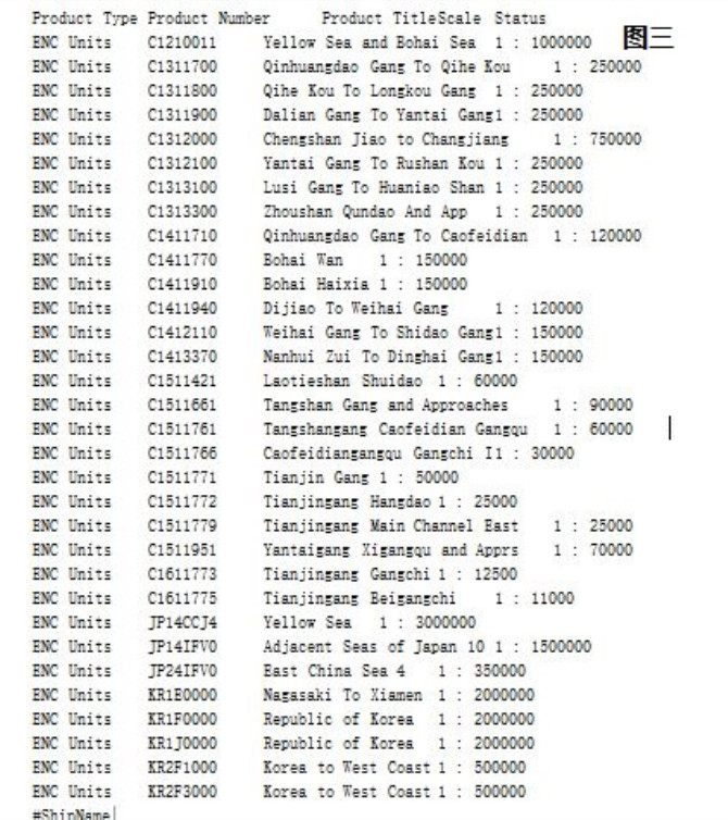
The result obtained from the above automatic charts selection is that 32 charts are related to this route. If you want to purchase these 32 charts, it must meet all the requirements of the Convention and other specifications. And this method of selection is the most direct and secure onewithout any doubt, but the question is whether these 32 maps really need to be purchased or not?
There are two ways to manually select the charts. One is from large to small, that is, from large scale charts to the smallest scale, and the other is from small to large, and the choice of scale charts is exactly the opposite. The following is an example of chart selected step by step from a small scale.
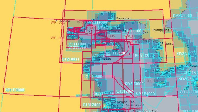
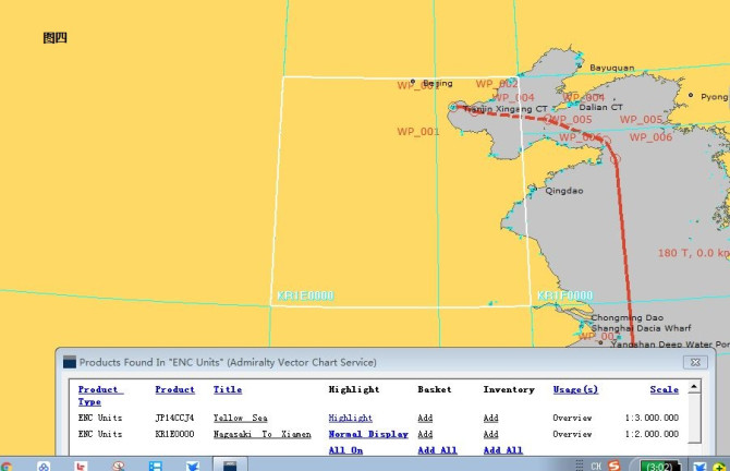
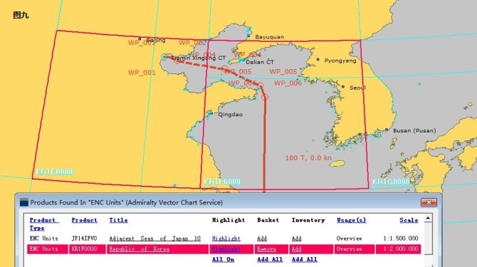
First, cancel all scales below the overview so that only the overview charts left on the chart. Click on the first section of the route and two overview charts cover the routeappear, JP14CCJ4 (Figure 4) and KR1E00 (Figure 5).
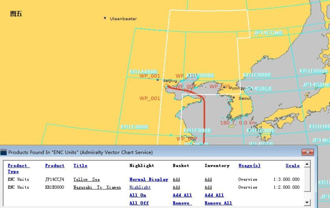
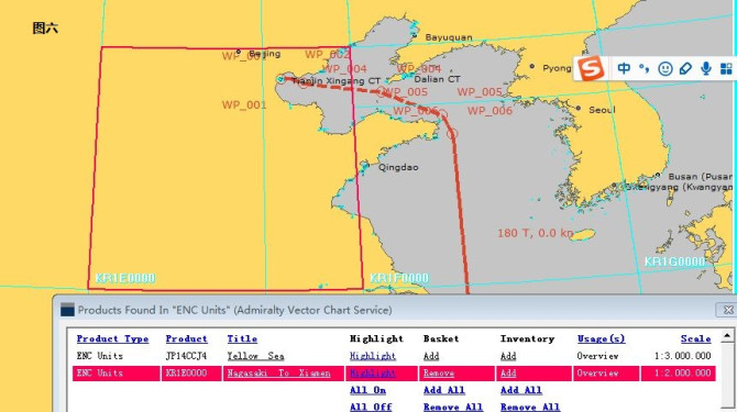
It can be seen that the KR1E0000 is larger than the JP14CCJ4 scale and the coverage is more reasonable, so it is appropriate to select the KR1E0000 (Figure 6).
Then select the overview charts covered by the next section of the route. You can see two overview charts, KR1F0000 (Figure 7) and JP14 IFV0 (Figure 8).
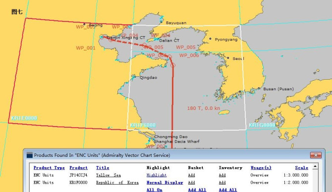
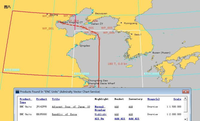
Comparing the two charts, it was found that although the KR1F0000 scale is larger than JP14 IFV0, it is better to cover and connect, so choosing KR1F0000 is more appropriate (Figure 9)
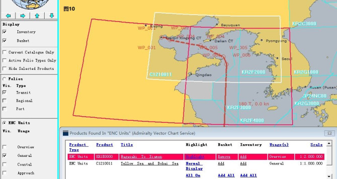
The remaining route can be configured for the overview scale section according to the above requirements, followed by the removal of the overview scale option. Check the general scale chart. At this time, it was found that the C1210011 chart covered the entire route (Figure 10) and the chart was added to the basket (Figure 11).
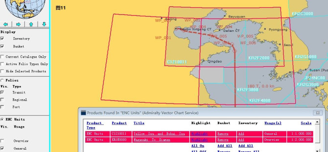
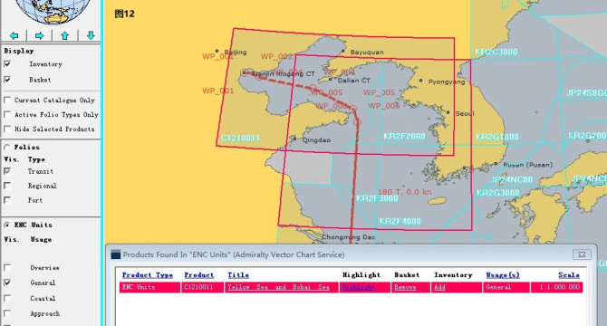
Comparing Figure 11, it was found that C1210011 can cover the entire route including the nearby sea area, so the KR1E0000 chart on the left can be considered for removal, which can fully guarantee safe navigation. (Figure 12)
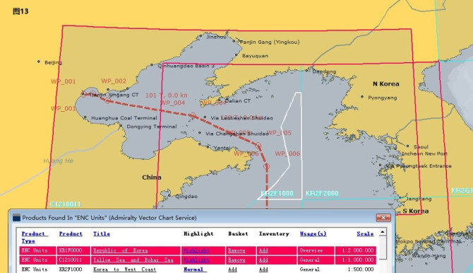
Then continue to configure the general scale of the remaining segment. This is the discovery that only one small corner of the KR2E1000 chart is covered on the route (refer white color part). In this case, to purchase this chart is completely unnecessary (Figure 13)
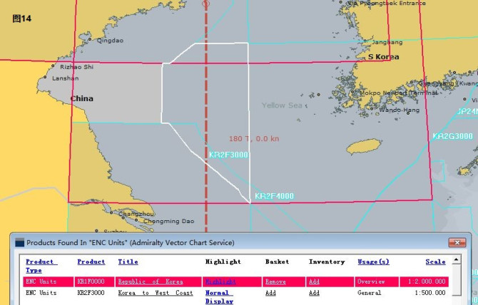
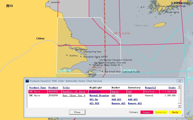
The remaining KR2F3000 (Figure 14) and JP24 IFV0(Figure 15) are covered on the route, so consider purchasing.
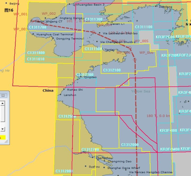
When the general scale chart is completed, the option is also removed and choose the Coastal scale chart. Since the scale chart (yellow) covers most of the routes, it is considered for purchase(Figure 16).
Through this way continuously select approach scale chart, and charts covering most of the routes are also selected for purchase. (Figure 17)
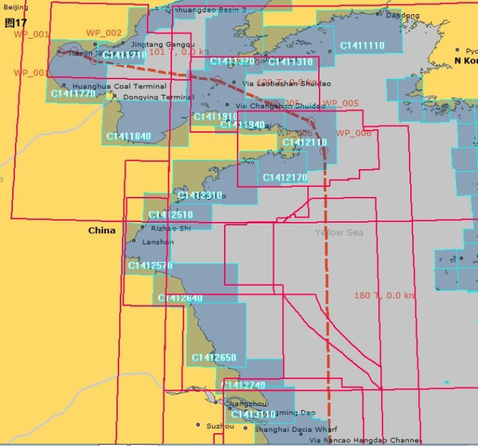
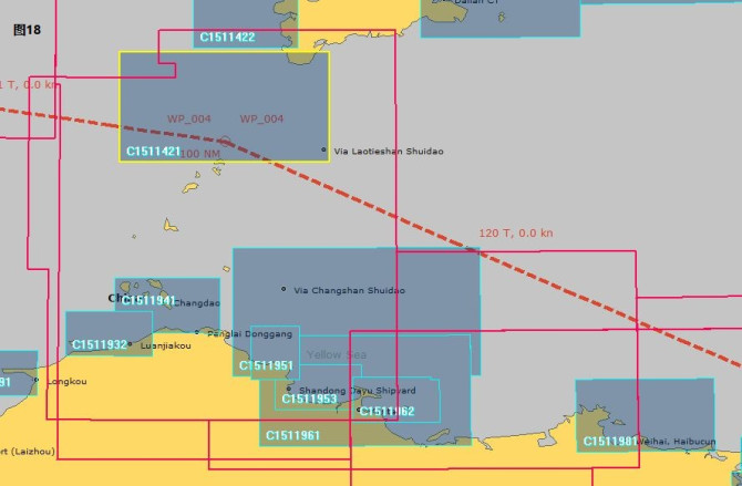
During selecting the harbor chart, it can be seen that C1511421 covers most of the routes, so it is considered for purchase, but C1511951 only has one small corner to cover the route, so it is not necessary to purchase. (Figure 18)
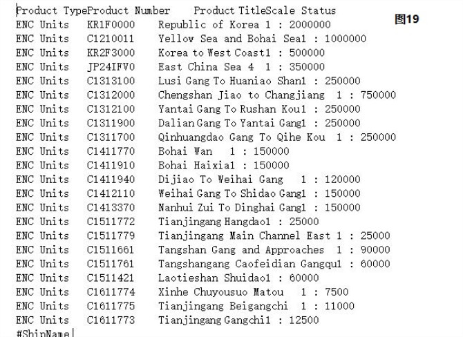
According to this principle, the chart selection will ensure that the different scale charts is covered on the route and meets the navigation requirements. After this choice, we checked the requisition list and found that a total of 22 charts were needed. Compared with the previous automatic selection, we can save 10 charts cost. This is only the short distance from Tianjin to the ZJK. (Figure 19)
We hope that through the above demonstration, we can tell everyone that automatic chart selection can certainly guarantee security, butitis unnecessary to make additional cost for purchase. However, PSC can’t make out deficiency as vesselis not fully configured with all charts relate the route. This is unreasonable.
It is hoped that with the above explanation, you will be able to understand how to reasonably acquire nautical charts and how to communicate with the inspector about nautical charts in order to ensure the safety of navigation of ships while avoiding unnecessary costs. welcome to correct if any comments.
Source: 湖北新海联船员培训中心 副总经理 首席培训师 陈浩船长
The opinions expressed herein are the author's and not necessarily those of The Xinde Marine News.
Please Contact Us at:
admin@xindemarine.com


.gif)


 Ningbo Containerized Freight Index Weekly Commentar
  Ningbo Containerized Freight Index Weekly Commentar
  BIMCO Shipping Number of the Week: Bulker newbuildi
  Ningbo Containerized Freight Index Weekly Commentar
  Ningbo Containerized Freight Index Weekly Commentar